Wednesday, September 18, 2013

East Coast 2013 - Day 6

September 4/13 - Fogbound in Harbour Breton! 

The fog and damp descended with a vengeance, at one point obscuring the town and harbour before our very eyes. We hunkered mainly at the vacant campground, and took full advantage of the laundry facilities to dry our stuff and also as a good place to sit and read during the incessant drizzle. We even cooked in there!

With the snaking roads and prevalence of moose, we decided not to stray too far in the fog. We did explore Harbour Breton itself a little further, including the site of a tragic landslide in 1973 that swept a number of houses right into the bay and claimed the lives of four young children. To this day, the hillside above remains a barren scar on an otherwise verdant canvas.

Crossed the causeway to the "north side" of the harbour and also enjoyed some local flavour at the Hook n' Line Lounge, where we had some interesting conversation with the owners and a few locals over a beer or two....before returning to the campsite. We spent the last night in town sleeping in the car, preferring dry and uncomfortable seats over a wet tent and air mattress.

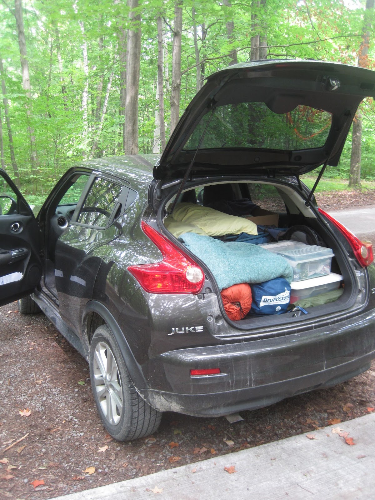
Putting the "dry" in laundry

Facilities to ourselves at Deadman's Cove

The road leaving the campground

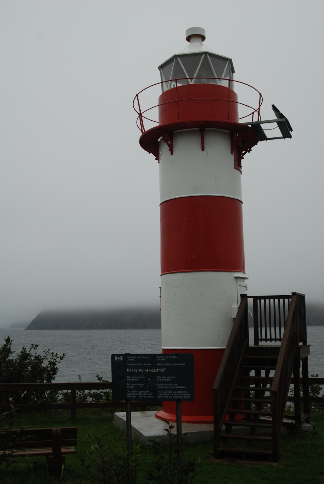
Rocky Point lighthouse

A bog in the fog

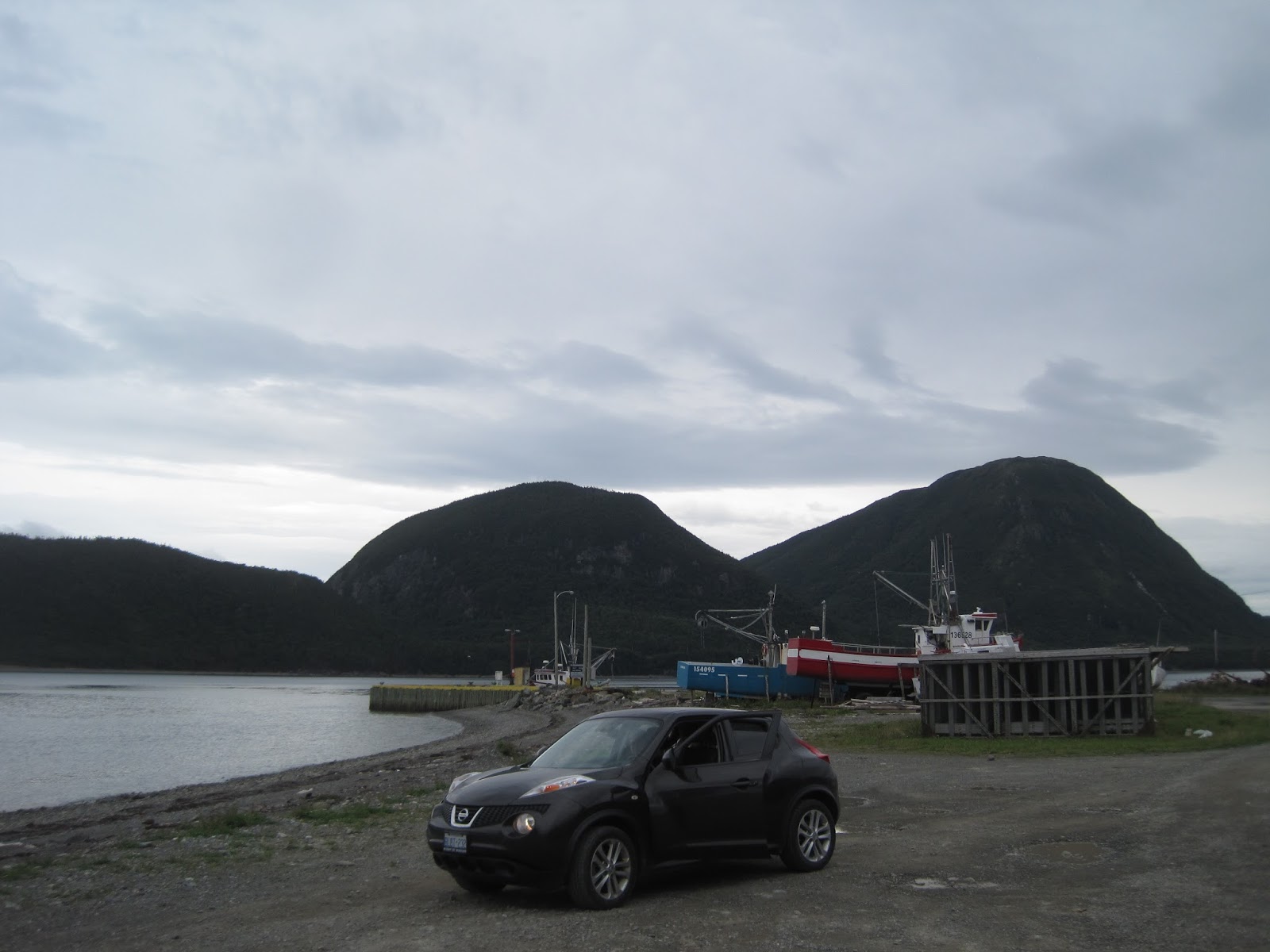
Whatever floats your boat

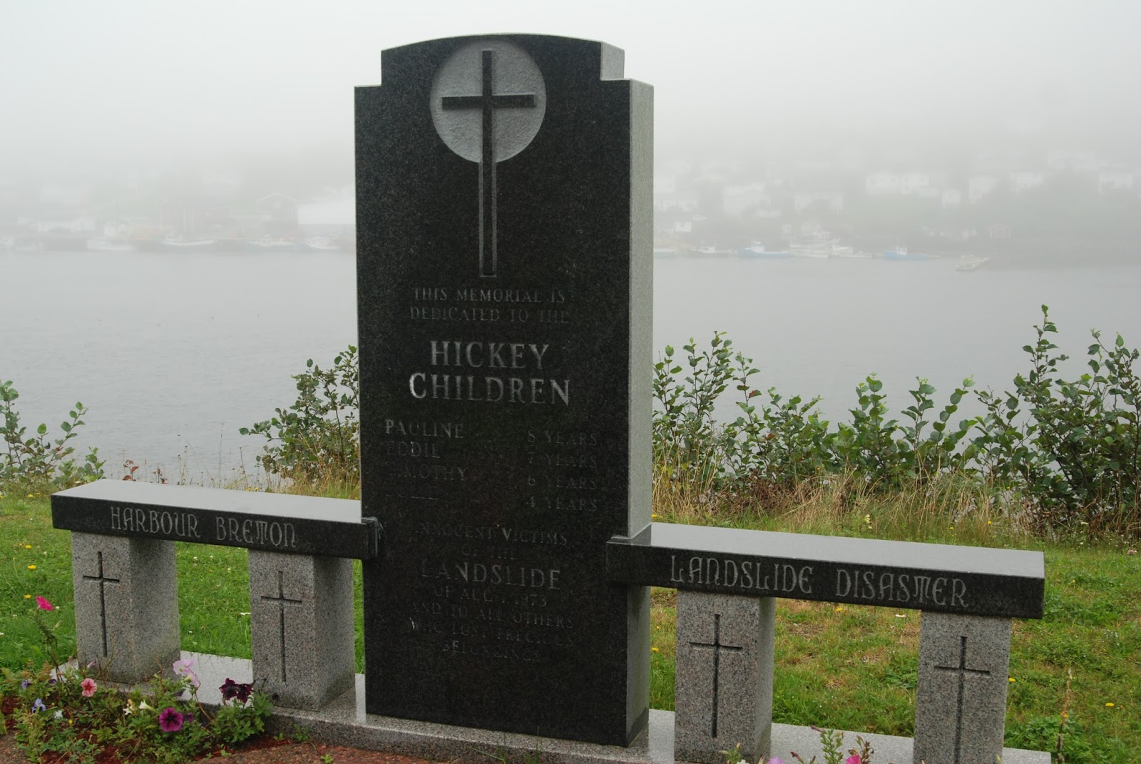
Memorial for victims of the terrible 1973 landslide

Anglican cemetery with a view to die for

Tuesday, September 17, 2013

East Coast 2013 - Day 5

September 3/13 - Connaigre Peninsula 

We spent the next day exploring the other two arms that make up the trident-shaped peninsula, and the various isolated communities that grace their rugged shores. We spent pretty much the whole day exploring Routes 362, 363 and 364 as they branch off the 360 to the east and west, though with constant stops the day did not feel long.

At Seal Cove, we made a long hike into the resettled community of Pass Island, but not quite long enough. We had already driven the Juke partway in down the sketchy road, likely a few deep "puddles" further than we should have, before we set out on foot....mainly for four-wheelers, rather than cars. We never did make it all the way in before we had to turn back as the return road grew long and the weather worsened. Very scenic and relaxing stroll all the same.

One other thing about this particular part of Newfoundland - the Cox name is quite prevalent. We keep hoping to discover that Jane stands to inherit an entire fishing village or small island or something.

These pictures should tell the tale, far better methinks, as words will fail.

Hermitage

Route 362

The road to Belleoram

Wreck Cove

Route 363

Harbour Breton

Deadman's Cove

The hike into Pass Island

Hermitage, Revisited

Belleoram

English Harbour West

They're everywhere!

East Coast 2013 - Day 4

September 2/13 - Corner Brook - Grand Falls - Harbour Breton

Made the return jaunt along Humber Arm back to Corner Brook to start the day, before rejoining the Trans-Canada Highway (aka Hwy 1) to continue our journey east. Fairly uneventful day of driving, at least as far as Grand Falls-Windsor, close to where we planned to diverge again from the TCH and head straight south to the isolated Connaigre Peninsula along Newfoundland's south-central coast.

At Bishop's Falls we made the turn, taking Route 360 south for an expected two hours of barren wilderness. What we did NOT expect was a road washout about a third of the way in, which held us up for a bit and they brought dump trucks in around us to dump fill on the road, which a backhoe then swept in to plug the holes.

Finally made it in to Harbour Breton, the main town along the southern peninsula. Gorgeous little fishing village nestled amongst the steep fjords, and complete with all the necessities we would need to spend three days staying relatively local.

We set up camp at Deadman's Cove.....though I had neglected to tell Jane just where the name came from. Or that there were cemeteries very nearby. Given the late season, we had the whole place to ourselves.....at least among the living.

TCH East through Corner Brook area - note the exit to Cox's Cove!

Hilarious sign at Grand Falls-Windsor McDonald's - beware!

Route 360 almost required us to do a 180!

Campsite #2 at Deadman's Cove

Guardians of the Cove

The Barrenlands

Harbour Breton from the North Side
Harbour Breton strung along Southwest Arm

Sunday, September 15, 2013

East Coast 2013 - Day 3

September 1/13 - Western Newfoundland - Corner Brook 

Our floating hotel plowed onward into the night, as we grabbed a fitful nap in some reclining lounge chairs. The newer boats definitely had a more decorative and comfortable interior, though the area free for passengers to wander seemed more confined than the old ships.

The Blue Puttees docked in Port-aux-Basques at dawn, with more traffic chaos getting cars up out of "the hole". We lost another half-hour to the Newfoundland time zone, but the spirited Juke made short work of the traffic ahead once we hit the Trans-Canada Highway.

After two long days on the road and a night spent "sleeping" on the ferry, we opted for a relatively short day. We went as far as Corner Brook, about two hours in, and after a short supply stop we headed west out the scenic Harbour Arm to camp at Blow-Me-Down Provincial Park in the Bay of Islands, near the fishing village of Lark Harbour.

The tent was quickly erected and camp set up, before we explored the area a little further, climbing the nearby Governor's Staircase in the rock face, and visiting the Drop In Lounge in nearby Lark Harbour for a beverage and some darts with the locals.

With rain threatening, dinner consisted of hot dogs boiled over the propane burner, followed by a nice hot cup of pressed coffee.

Arriving in Port-aux-Basques, Newfoundland at dawn

The fabled high wind area known as The Wreckhouse

City of Corner Brook and the waters of Humber Arm

End of Route 450 in Lark Harbour

View from atop the Governor's Staircase

The oceanfront beach at Blow-Me-Down

The sign says it all!

Campsite amidst the rugged Blomidon hills

East Coast 2013 - Day 2

August 31/13 - New Brunswick and Nova Scotia

With a ferry to catch, we had to continue to cover ground on the second day, from northern Quebec right through to North Sydney, Nova Scotia. We said farewell to Quebec in a heavy fog, and settled in for another long day of driving....which included losing an hour as we crossed into Atlantic time.

We still had time for the odd short stop, including surprising Jane with a stop at a potato chip factory in Hartland, New Brunswick.....you can tour the factory and get a bag of fresh chips, hot off the line. Somehow she missed all the signs as we drove up (likely busy posting something on Facebook), so when she looked up and saw a big stainless steel tank, she assumed I had taken her to a micro-brewery!

Of course, one can't stop in Hartland and not visit the world's longest covered bridge, for which the chips are named anyway....

By afternoon, we were well into Nova Scotia. We crossed the Canso Causeway into Cape Breton, and made our way to the Marine Atlantic ferry terminal to await our midnight crossing on the MV Blue Puttees, one of several new ferries since our last visit to The Rock. We started boarding at about 930pm, part of a bizarre new loading strategy to get us on early and then sell us more food and drink. The reasoning behind early loading also become evident when we saw the "new" boarding method.

Apparently the new boats have a special compartment in the very belly of the ship, with a ramp that closes and becomes part of the deck above.  The best part is that they send a few cars down the steep ramp at a time, and have people pull U-turns and back up into marked lanes.....not everyone is good at backing up or maneuvering in tight spaces, let's just say.....and also means you're last off as they have to empty the entire deck above before they can lower the ramp again.

At any rate, we were on the water and headed for Newfoundland at 1159pm.....

Nearing Edmunston, NB and about to lose an hour!

Mmmmmmm....fresh chips!

Well worth a stop if you're passing through Hartland - right off the highway!

The bridge at Hartland - one lane only, so wait your turn!

New Brunswick Highway 2 becomes Nova Scotia Highway 104

Canso Causeway

Waiting for the ferry....

Our ferry, the MV Blue Puttees

Bizarre parking "down in the hole" on the lowest level of the ferry

East Coast 2013 - Day 1

August 30/13 - Ontario and Quebec

 So we set off early for the East Coast, with the Juke fully laden for two weeks of camping. Not much in the way of interest to share, pretty much spent the day driving the length of Ontario and most of Quebec.

Did find a "better way" to deal with Montreal than previous trips, which worked out well until Friday-of-a-long-weekend evening traffic intervened on the far side of the city. Nice little side route that skirts south of the city and then up the east side of the St. Lawrence, misses most of the chaos.

Ended the day just south of Riviere du Loup, Quebec, after a long day behind the wheel.


Loaded Juke at shaded picnic spot

Lunch break near Trenton, Ontario

Crossing from eastern Ontario into Quebec

My view for about 14 straight hours....

Thursday, August 29, 2013

One More Sleep...

Heading out tomorrow, and what better way to kick off a road trip than a Shawinigan Handshake? I don't think we'll get far enough up the west bank of the St. Lawrence to visit Chretien's home town in person, but we'll wave from across the river as we speed East.

Let me just say that as a federal public servant, I just wish more of our political leaders ended up gracing beer bottle label art as a result of throttling hecklers. What a magical world that would be.

Stay tuned - stunning scenery pics from Newfoundland and Cape Breton to follow in the coming days, or at worst, when we get home again.....